

Conybeare and Dawson’s Memoir and Views of Landslips on the Coast of East Devon &c. 1840
To open a detailed view of any page click on the picture
In 1840 Lyme geologists Rev William Conybeare and Dr William Buckland produced the first fully scientific report ever produced about a major landslip – the Bindon Landslip of 1839. It was beautifully illustrated with coloured maps and sections by William Dawson and engravings by Mary Buckland. Their conclusions are still valid. As the originals are fragile, we present this report here in full for your enjoyment. William Dawson also produced a model of the landslip – follow the link to read Thea Hawksworth’s paper on this model, which is in the Museum, and how the landslip happened. Click here to read the paper.
-

- Cover of Conybeare and Dawson’s Memoir and Views of Landslips on the Coast of East Devon &c. 1840

-

- Ten Plates

-

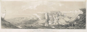
- Plate I. Geological View of the Coast from Lyme regis in the County of Dorset to Axmouth Harbour on the East Coast of Devon

-

- List of Subscribers

-
- Contents

-

- Preparatory Remarks

-
- Description of the Local Circumstances of the East Devon Undercliff

-
- Narrative of the recent founder or landslip which began on Christmas Day 1839

-

- Particular description of the Great Chasm and elevated submarine reef; with observations on the theory of landslips or founders to explain their formation.

-
- The Great Chasm – continued.

-

- Description of the elevated submarine reef, and remarks on the probable causes for its formation.

-

- Account of the great subsidence of a portion of the chalk cliffs, and elevation of submarine rocks near Beer, in the Spring of 1790

-

- Account of the Subsidence of the land and elevation of the beach near the base of the Whitlands cliff. Plate II. & IX.

-

- Enumeration of similar founders and landslips which have been recorded to have happened at previous periods and in other locations.

-

- Account of landslips (strictly so called) in the highly inclined Silurian rocks in Shropshire and Herefordshire.

-

- Alpine ecroulemens and Conclusion. – Recapitulation of arguments evincing the Bindon and Dowland’s cliffs not to have been produced by an earthquake.

-

- Appendix No. 1 – Account of the subsidence or founder at Hawkley Hanger.

-

- Appendix No. 2 – Earth falls at the undercliff, Isle of Wight

-

- Appendix No. 3 – On the relations of other similar geological phaenomena.

-

- Plate II. Ground plan and sections of the great landslip ar Great and Little Bindon and Dowlands in the parish of Axmouth on the east coast of Devon

-

- Plate III. Geological section of the Chasm, Undercliff and new raised beach from the eastern boundary of Great Bindon to the sea

-

- Plate IV. A view of the landslip from Great Bindon

-
- Plate V. View of the Axmouth landslip from Dowlands

-

- Plate VI. View of the Great Chasm from its western end at Bindon

-

- Plate VII. View from the new beach

-

- Plate VIII. View from the western end of the beach near Culverhole Point

-
- Plate IX. View of the landslip at Whitlands

-

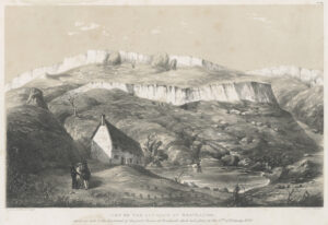
- Plate X. Landslip under Southdown between Beer and Branscombe

Peter Lincoln’s Ten Views of a Landslip
Peter Lincoln, Editor of GeoHistories, the magazine of History of Geology Group (historyofgeologygroup.co.uk) has kindly allowed us to post his personal appreciation and analysis of the Great Bindon Landslip in its historical and scientific context. It includes his recollection of one of Lyme’s most devoted 20th Century visitors, his teacher Muriel Arber. Click here to read his account…